The Puy de Dôme, a leading site for paragliding
The Puy de Dôme (1,465 m) is the most popular and charismatic volcano in mainland France, and was awarded the “Grand site de France” label in 2008. It is the most visited place in Auvergne with more than half a million visitors per year. It is part of one of the world’s most representative volcanoes: the Puys chain, located in the heart of the Massif Central. The Puy de Dôme is a monogenic (one eruption) explosive volcano of the Pelean type that has been dormant for about 12,000 years. It is made up of two interlocking blocks of trachyte, the result of two successive eruptions a few hundred years apart. It rests on a granitic plateau located at an altitude of 1,000 metres, like all the volcanoes in the Puys chain.
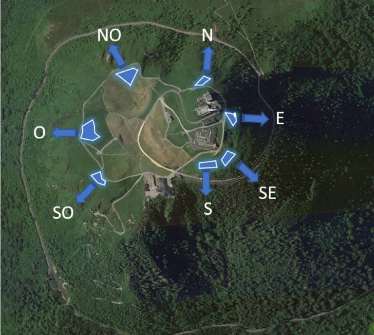
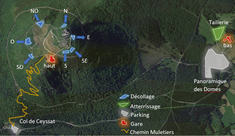
With a difference in altitude of around 500 metres and eight take-off zones allowing you to take off regardless of the wind direction, it is one of the most privileged areas for paragliding.
The Puy de Dôme, a UNESCO World Heritage Site
Even more gratifying, the whole of the Puys chain and the Limagne fault is the first natural site in the metropolis to be classified as a UNESCO world heritage site since 2018. It is therefore a magical place to make your first paragliding jump, you will fly over the Puys chain by taking off a few steps from the Gallo-Roman temple dedicated to the god Mercury!
How to climb to the top of the Puy de Dôme?
The summit of the Puy de Dôme has been accessible by cogwheel train since 2012.
The timetable is available on the Panoramique des Dômes website. Please note that on certain weekends and during the summer period, you must come at least 20 minutes in advance so as not to miss the train for your appointment, due to the large number of people.
There is always a road, but it is reserved for the rescue services and the staff who work at the summit.
It is possible to climb the summit on foot via hiking trails. The wide footpath, known as the “sentier des muletiers” (muleteers’ path), starts at the Col de Ceyssat (1,078 m) and leads, via a series of switchbacks, to the Temple of Mercury (1,450 m). This trail is 2 km long and has a difference in altitude of 390 metres, i.e. an average gradient of 19%. It takes 40 minutes for regular walkers.
The second pedestrian access is from the north and follows the GR4. It is accessible by crossing the landing until you meet the path of the old tollgate, you have to follow a path on the left which goes up to the fountain of Traversin at 1125 meters of altitude, where there is a kind of crossroads going towards the puy de Dôme, the puy Pariou and the puy de Côme. If you take the 2 km long Puy de Dôme path, you will soon find wooden steps and pontoons that lead you to the road that you will follow for 200 metres to the summit.
Benefit from a 10% discount on your train tickets!
By buying your tickets directly online at Panoramique des Dômes.